


Whether viewed through the lens of history, law, or politics, those maps continue to challenge simplistic narratives and force difficult questions about the origins of the present conflict. History may be debated. Interpretations may differ. But the historical record remains. And the maps of 1960 are still there.
By Timothy Enongene
Guest Editor-in-Chief, The Independentist News
The Maps That Refuse to Disappear
Yaoundé – June 11, 2026 – For decades, the authorities in Yaoundé have promoted the doctrine that Cameroon is “one and indivisible.” That principle has become the foundation upon which the state justifies its authority over the former British Southern Cameroons and rejects demands for self-determination. Yet beneath the political slogans lies a historical question that has never disappeared and that continues to challenge official narratives: what were the internationally recognized borders of La République du Cameroun at the moment it achieved independence on January 1, 1960?
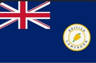
The answer is neither emotional nor ideological. It is found in the maps, treaties, United Nations records, and official documents of the period. Those records show that when La République du Cameroun became independent from France on January 1, 1960, the territory known as British Southern Cameroons was not part of its internationally recognized boundaries. Southern Cameroons remained a separate United Nations Trust Territory administered by the United Kingdom under the authority of the United Nations Trusteeship System. The significance of that historical reality continues to reverberate across the political landscape of Central Africa today.
Two Territories, Two Histories
One of the most persistent misconceptions surrounding the Southern Cameroons question is the assumption that the territory was somehow an internal region of Cameroon prior to 1961. Historical records tell a different story.
French Cameroun and British Southern Cameroons evolved under entirely different colonial administrations. They possessed different legal systems, different educational traditions, different administrative cultures, and different constitutional arrangements. By the time independence arrived for French Cameroun in 1960, Southern Cameroons remained under a separate international trusteeship arrangement awaiting the determination of its political future. The distinction was not merely administrative. It was recognized by the international community.
When Southern Cameroons entered the United Nations-supervised plebiscite process of 1961, it did so not as a province of French Cameroun but as a distinct trust territory whose future remained unresolved.
The Legal Significance of January 1, 1960
The date January 1, 1960 occupies a central place in the legal arguments advanced by many Southern Cameroonians. On that day, La République du Cameroun achieved independence within borders recognized by the international community.
Under the principle of uti possidetis juris, the borders inherited at independence acquire particular legal significance. Throughout Africa, this principle has served as one of the foundations for preserving territorial boundaries and avoiding endless disputes over colonial frontiers.
For many Southern Cameroonian scholars and legal advocates, this raises an obvious question. If Southern Cameroons was outside the recognized borders of La République du Cameroun on January 1, 1960, by what legal process was sovereignty subsequently extended over the territory? That question remains at the center of ongoing historical and legal debates.
More Than a Border Dispute
The Southern Cameroons question has never been solely about maps. It is also about institutions, identity, and political culture. Prior to unification, Southern Cameroons possessed its own House of Assembly, House of Chiefs, judiciary, educational system, and administrative traditions. Many Southern Cameroonians argue that these institutions reflected a distinct political culture rooted in accountability, local governance, common law traditions, and representative administration.
Whether one agrees with that interpretation or not, there is little dispute that the territory entered the post-colonial era with a historical experience markedly different from that of French Cameroun. The continuing tension between these two traditions remains one of the defining features of the modern conflict.
Why the Historical Record Matters
Governments may change. Political narratives may evolve. Generations may pass. Yet historical documents retain a stubborn permanence. Maps produced by colonial administrations, records maintained by the United Nations, diplomatic correspondence, constitutional texts, and official archives continue to exist regardless of contemporary political preferences. They remain available for scholars, diplomats, lawyers, and future generations to examine.
For this reason, the debate over Southern Cameroons cannot be resolved simply through political declarations. It inevitably returns to the documentary record and to the historical circumstances that existed at the end of the trusteeship period.
The Enduring Question
More than six decades after the events of 1960 and 1961, the central question remains remarkably simple. – Were the people of Southern Cameroons incorporated into a political arrangement consistent with the principles of international law and self-determination, or did subsequent developments depart from the expectations and understandings that existed at the time? Reasonable people continue to disagree on the answer. What cannot be disputed is that the historical maps of 1960 continue to occupy a central place in that discussion.
Conclusion
For Ambazonians, the significance of the 1960 maps extends far beyond cartography. They represent a historical record of a territory that existed separately from La République du Cameroun at the moment of independence. They remind the world that the Southern Cameroons question did not emerge from nowhere and that its roots are embedded in the complex legal and political processes of decolonization.
Whether viewed through the lens of history, law, or politics, those maps continue to challenge simplistic narratives and force difficult questions about the origins of the present conflict. History may be debated. Interpretations may differ. But the historical record remains. And the maps of 1960 are still there.
Timothy Enongene
Guest Editor-in-Chief, The Independentist News